Thursday, 5 January 2012

Dog Proof Fence

Heading to the Flinders Ranges in South Australia we stopped briefly at Wycheproof, a small regional town in the centre of the Shire of Buloke, in North Western Victoria. Mount Wycheproof is a mountain located in the town. Standing at 43 metres (141 ft) above the surrounding terrain, Mount Wycheproof has the distinction of being the smallest registered mountain in the world.

iPhone 4
Click on photo for larger image view

43 Kms further North West on the Calder Highway, near Culgoa is a historic marker for the dog proof fence  (Click text to view in Google Maps) This marks the site of the dog netting fence which crossed the highway at this point. Part of the fence is included with the memorial. The fence stretched approximately 325 kilometres from Tyntynder on the Murray River to the South Australian border and was intended to prevent wild dogs and other vermin entering farmlands to the south.
 iPhone 4
Click on photo for larger image view

iPhone 4
Click on photo for larger image view

Sunday, 1 January 2012

4x4 self drive tour of SKYTREK

Just back from a 4x4 self drive tour of SKYTREK, one of the Flinders Ranges most popular and exhilarating 4WD journeys. Rated as one of the top 20 4x4 treks by Australian 4WD Action Magazine
RATING
Remote: 6/10
Scenic: 10/10
Iconic: 9/10
Adventure: 10/10
Challenging: 6/10

Photo's soon but in the meantime here's the promotional video from YouTube

Friday, 23 December 2011

Who? Whroo . . .

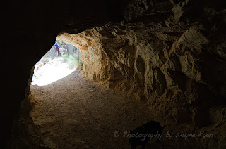
Whroo Historic Reserve is on 500 hectares near Rushworth in Victoria and contains the Whroo township an old gold mining ghost town in the Whroo goldfields. The town once had over 140 buildings and a cemetery on Spring Hill near the town site. The last resident of the town left in the early 1960s. Mine shafts dot the area and the Balaclava open cut mine has a mine tunnel running through Balaclava hill into its centre.
Nikon D300, Nikkor 35mm f2D @ ISO 200, 35mm f16, 1/250 sec
Click on photo for larger image view
Nikon D300, Nikkor 35mm f2D @ ISO 200, 35mm f2.8, 1/800 sec
Click on photo for larger image view

 Nikon D300, Nikkor 35mm f2D @ ISO 1600, 35mm f2.8, 1/80 sec
Click on photo for larger image view
   Nikon D300, Tokina 11-16 f2.8 @ ISO 560, 11mm f8, 1/80 sec
Click on photo for larger image view
  Nikon D300, Tokina 11-16 f2.8 @ ISO 1600, 11mm f8, 1/40 sec
Click on photo for larger image view
   Nikon D300, Tokina 11-16 f2.8 @ ISO 320, 11mm f22, 1/80 sec
Click on photo for larger image view
   Nikon D300, Tokina 11-16 f2.8 @ ISO 280, 11mm f22, 1/80 sec
Click on photo for larger image view
Tuesday, 20 December 2011

Saturday, 17 December 2011

Victorian Desert Tracks I

Wyperfeld National Park is open plains and mallee eucalypts, with a usually dry Outlet Creek through the middle that has flowed three times in the last 100 years. Outlet Creek is the overflow from Lake Albacutya and runs through the park and linking a series of lakes (also usually dry). Some of the 4x4 tracks that wind through what is classed as 'remote wilderness'. I entered from the Patchewollock eastern side and only ran down from Yarto (-35.498832,142.272091) to Dattuck Road (-35.588033,142.385881) partial track logged *here* in the park.
 Nikon D300, Tokina 11-16 f2.8 @ ISO 200, 11mm f16, 1/125 sec
Click on photo for larger image view 
 Nikon D300, Tokina 11-16 f2.8 @ ISO 400, 11mm f22, 1/80 sec
Click on photo for larger image view  
  Nikon D300, Tokina 11-16 f2.8 @ ISO 900, 11mm f22, 1/80 sec
Click on photo for larger image view 
 Nikon D300, Tokina 11-16 f2.8 @ ISO 200, 11mm f2.8, 1/3200 sec
Click on photo for larger image view  
  Nikon D300, Tokina 11-16 f2.8 @ ISO 200, 11mm f2.8, 1/250 sec
Click on photo for larger image view 
  Nikon D300, Tokina 11-16 f2.8 @ ISO 200, 11mm f2.8, 1/2000 sec
Click on photo for larger image view 
 Nikon D300, Tokina 11-16 f2.8 @ ISO 200, 11mm f16, 1/200 sec
Click on photo for larger image view 
The Old Drive In Theatre at Birchip - CLOSED
 Nikon D300, Tokina 11-16 f2.8 @ ISO 720, 11mm f22, 1/80 sec
Click on photo for larger image view